Hebuterne Military Cemetery
- Country France
- Total identified casualties 720 Find these casualties
- Region Pas de Calais
- Identified casualties from First World War
- GPS Coordinates Latitude: 50.12555, Longitude: 2.63131
PLEASE NOTE
Following the works, a major grass restoration is needed around the Stone of Remembrance and along the restored walls, south and east walls. Please take care when visiting.
We apologise for any inconvenience caused.


Location information
Hebuterne is a village 15 kilometres north of Albert (Somme) and 20 kilometres south-west of Arras. Using the D919 from Arras to Amiens you will drive through the villages of Bucquoy, Puisieux then Serre-les-Puisieux (approximately 20 kilometres south of Arras). On leaving Serre-les- Puisieux, 3 kilometres further along the D919, turn right following the signs for Hebuterne. Hebuterne Military Cemetery lies to the west of the village and a CWGC signpost clearly indicates the way from the village green to the cemetery.
Visiting information
PARKING
There is no car park at the cemetery. There is a lay-by on the side of the main road (Rue de la Huie) directly in front of the main entrance. The surface of the layby is gravel and slightly sloping.
LAYOUT AND MAIN ENTRANCE
The cemetery is enclosed within a medium level red brick wall.
The main entrance into the cemetery is through a gap in the boundary wall. There is a low-level latched metal gate, opening approximately 800mm. The gate opens onto two flights of stone steps; one flight of steps, opens onto a flat area, then a second set of steps. The steps lead to a path going into the cemetery.
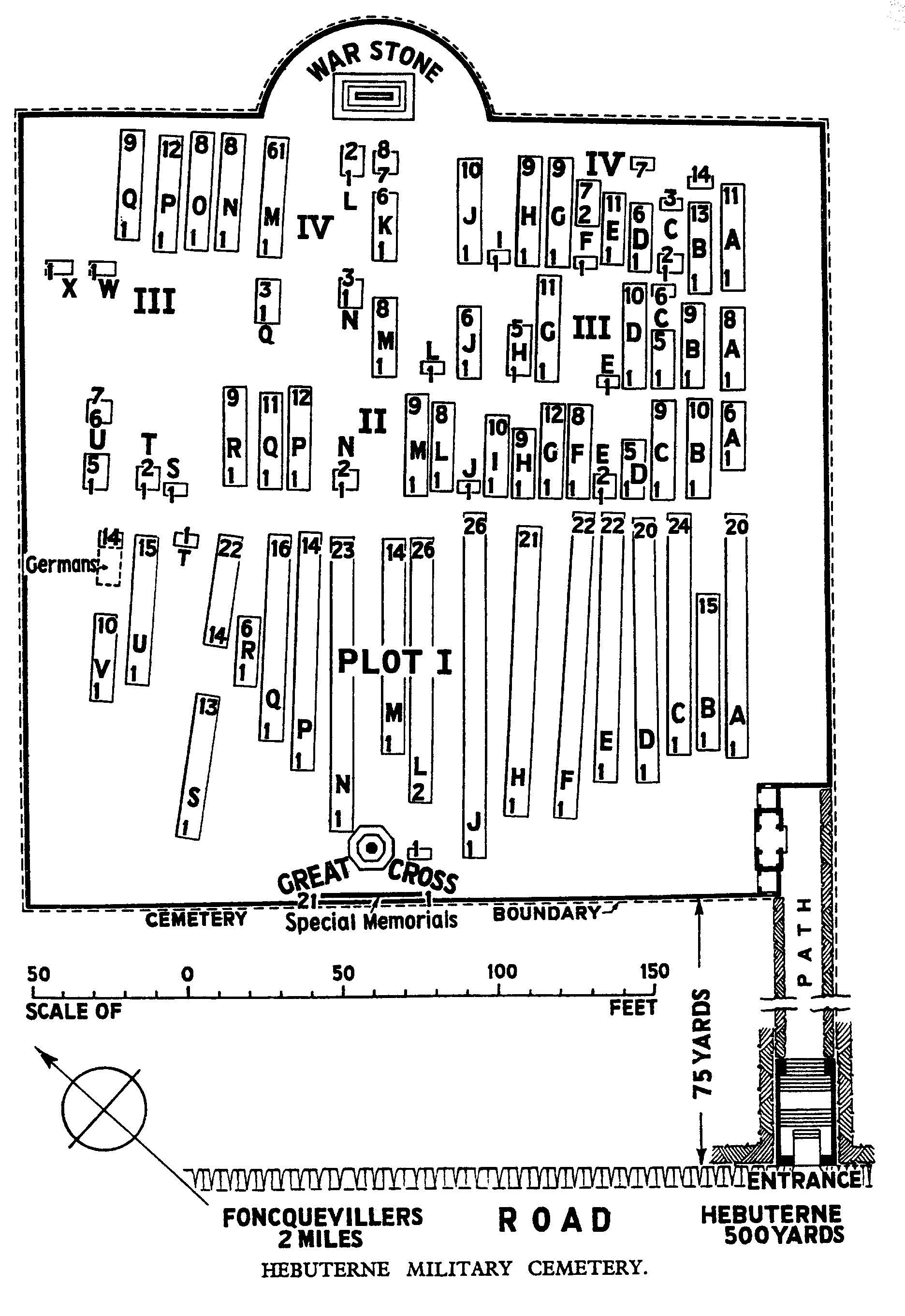
At the furthest point of the cemetery from the top of the steps, is a Stone of Remembrance. There are Special Memorials along the perimeter wall closest to the main entrance. There is also a Cross of Sacrifice close to the Special Memorials.
All paths inside the cemetery are grass and slightly sloping.
ALTERNATIVE ACCESS
There is a second entrance at the end of a farm track which follows along the line of the perimeter wall. The track is sandwiched between the cemetery perimeter wall and a barbed wire fence. The track is steep and covered with gravel and pebbles.
ADDITIONAL INFORMATION
There is a Register box close to the main entrance of the cemetery.
There are two seating areas in the cemetery, one stone bench is close to the main entrance and a second stone bench is inside the cemetery.
Hebuterne Military Cemetery is permanently open.
History information
The village gave its name to a severe action fought by the French on the 10th-13th June 1915, in the "Second Battle of Artois". It was taken over by British troops from the French in the same summer, and it remained subject to shell fire during the Battles of the Somme. It was again the scene of fighting in March 1918, when the New Zealand Division held up the advancing enemy; and during the following summer it was partly in German hands. It was later "adopted" by the Borough of Evesham.
Hebuterne Military Cemetery was begun by the 48th (South Midland) Division in August 1915, and used by fighting units and Field Ambulances (particularly those of the 56th (London) Division) until the spring of 1917; and it was reopened in 1918. The conditions of burial explain the irregularity of the rows.
There are now over 750, 1914-18 war casualties commemorated in this site. Of these, nearly 50 are unidentified and special memorials are erected to 17 soldiers from the United Kingdom, known or believed to be buried among them. The graves of two American soldiers have been removed from the South-West corner.
The cemetery covers an area of 6,502 square metres and is enclosed by a red brick wall.