Kandahar Farm Cemetery
- Country Belgium
- Total identified casualties 440 Find these casualties
- Region West-Vlaanderen
- Identified casualties from First World War
- GPS Coordinates Latitude: 50.75523, Longitude: 2.84748


Location information
Kandahar Farm Cemetery is located 14 km south of Ieper town centre on the Niewkerkestraat (N314), a road leading from the N365 connecting Ieper to Wijtschate, Mesen and on to Armentieres. From Ieper town centre the Rijselsestraat runs from the market square, through the Lille Gate (Rijselpoort) and directly over the crossroads with the Ieper ring road. The road name then changes to the Rijselseweg. On reaching the town of Mesen the first right hand turning leads onto the Mesenstraat (N314), which carries on to Nieuwkerke, via the village of Wulvergem. The cemetery lies 1 km after passing through the village of Wulvergem, on the left hand side of Nieuwkerkestraat.
Visiting information
ARRIVAL
The cemetery is not signposted.
PARKING
Parking is at the front of the cemetery along the outside of the perimeter wall. There is space for up to 4 vehicles to park along the front of the cemetery.
It is possible to park within 2 metres of the main entrance. The ground is compacted gravel at the far ends of the parking area, with paving stones and cobbles in front of the entrance. There is a curved road gulley between the parking area and the road (Nieuwkerkestraat).
ACCESS LAYOUT AND MAIN ENTRANCE
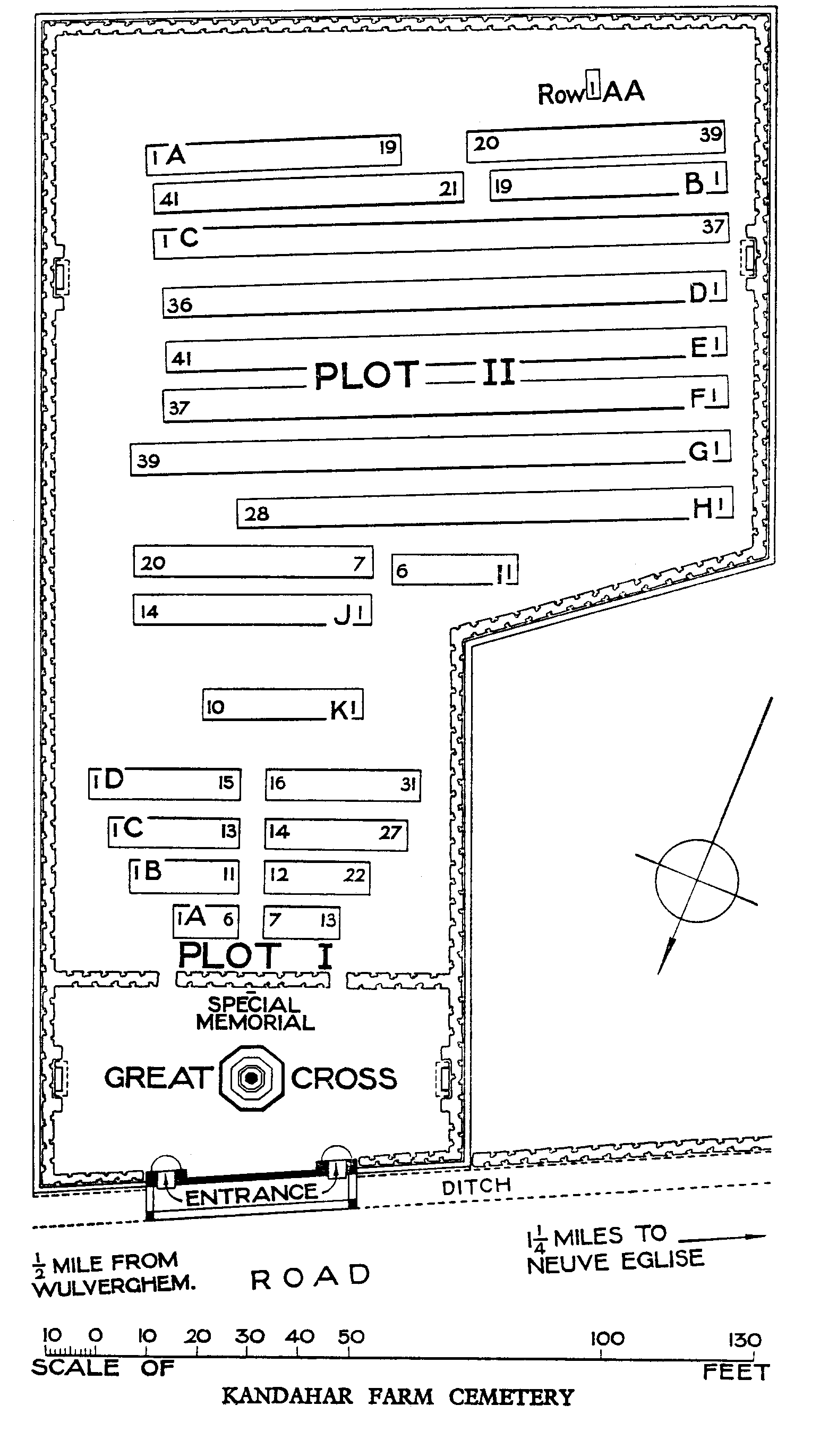
The cemetery is L-shaped with the narrowest part at the main entrance and widening at the middle of the cemetery. The cemetery is surrounded by a stone wall on all sides, with small sections of hedge along the front of the cemetery on either side of the entrance wall.
There are 2 mid-level, thigh height, black metal gates at either end of the front wall of the cemetery.
Each gate is 90 centimetres wide. Both gates have sliding latches with circular handles and open inwards into the cemetery. The left-hand gate has the latch on the right side of the gate. The paving under the gate is level with the exterior paving. The right-hand gate has the latch on the left side of the gate. Under this gate is a stone step down from the exterior pavement to paving inside the entrance. The paving inside both gates is semicircular and level with the grass.
The Cross of Sacrifice is immediately inside the entrance in the at the front of the cemetery.
There is a stone shelter building at the bottom left corner of the cemetery with stone benches inside. A single step up, approximately 200 mm tall leads inside. There is a narrow dirt strip 75 mm wide and 25 mm deep between the grass and the step.
Seating areas with stone benches are located at the front of the cemetery in line with the Cross of Sacrifice. An additional stone bench is located at the rear right side of the cemetery in line with the shelter building.
ALTERNATIVE ACCESS
The service entrance is on the far-right hand side of the cemetery at the end of the parking area to the right side of the cemetery.
Access into the cemetery is through a 140-centimetre-wide gap between a hedge and the perimeter wall.
The ground is flat and firm with a loose fine gravel and tarmac surface.
On the right of the service entrance is a black metal railing marking the end of the parking area. There is a ditch on the other side of the railing.
ADDITIONAL INFORMATION
The cemetery is permanently open.
History information
Kandahar Farm was near the village of Wulverghem (now Wulvergem) and for much of the war, the front line ran a little east of the village.
The cemetery was used by Commonwealth divisions holding this sector from November 1914 to April 1918, when it fell into German hands with the capture of Wulverghem and Neuve-Eglise (now Nieuwkerke). The two villages were recovered in early September and the cemetery was used again.
There are now 443 Commonwealth burials of the First World War in the cemetery.
The cemetery was designed by Charles Holden.