Wulverghem-Lindenhoek Road Military Cemetery
- Country Belgium
- Total identified casualties 659 Find these casualties
- Region West-Vlaanderen
- Identified casualties from First World War
- GPS Coordinates Latitude: 50.76402, Longitude: 2.84386
Location information
Wulverghem-Lindenhoek Road Military Cemetery is located 13 Kms south of Ieper town centre, on a road leading from the Kemmelseweg N331 connecting Ieper to Kemmel. From Ieper town centre the Kemmelseweg is reached via the Rijselsestraat, through the Lille Gate (Rijselpoort) and straight on towards Armentieres (N365). 900 metres after the crossroads is the right hand turning onto the Kemmelseweg (made prominent by a railway level crossing). 2 Kms after passing the village of Kemmel lies the left hand turning onto the Hooghofstraat. The cemetery lies 1.5 Kms along the Hooghofstraat on the right hand side of the road.
Visiting information
PARKING
The parking area is at the front of the cemetery outside the boundary wall. There is a concrete paved space for 2 vehicles, the ground is flat and firm.
The parking area is 50 metres from the main entrance and 10 metres from the alternative (service) entrance. There is a grass verge, which slopes down from the front wall to the road, approximately two metres wide along the front of the cemetery which can be used to get to the main entrance or the alternative entrance.
There is a grey concrete gulley between the parking area and side of the road. Care should be taken if crossing, as it is the same colour as the road
ACCESS LAYOUT AND MAIN ENTRANCE
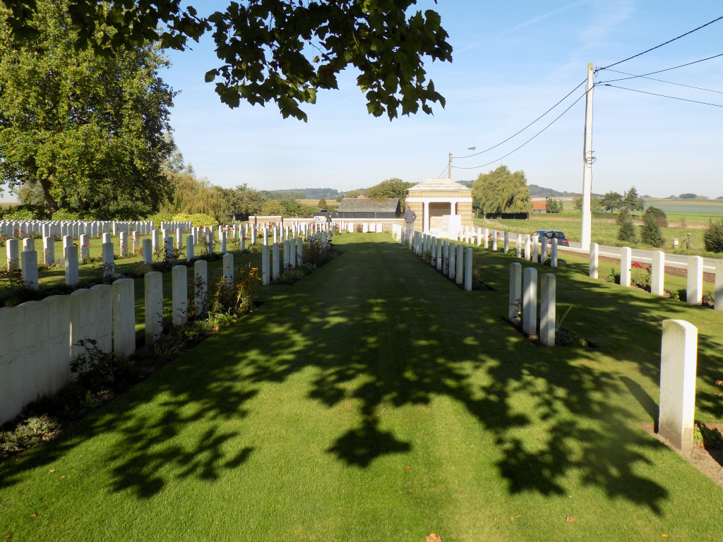
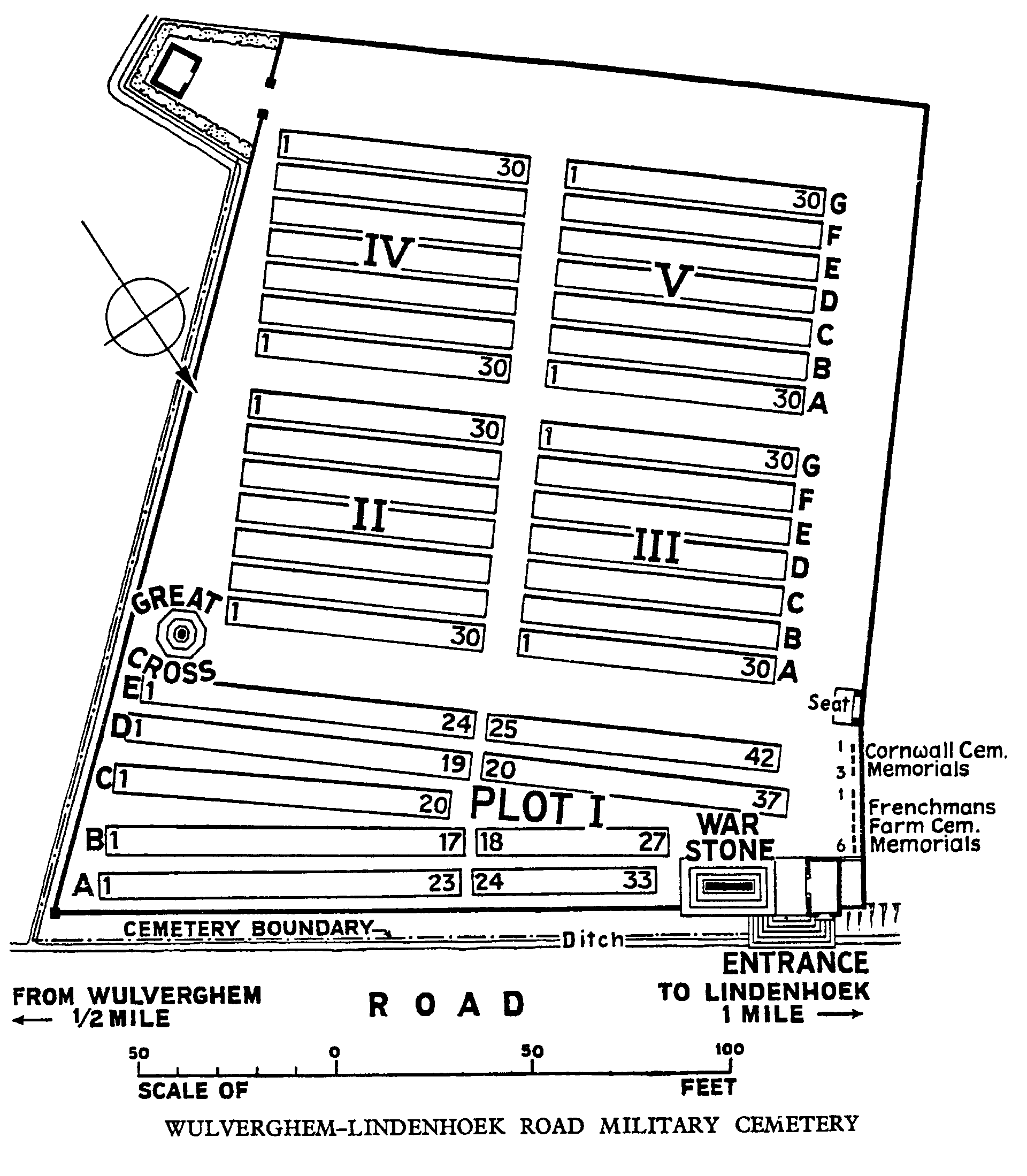
The cemetery is rectangular and runs parallel to the road and bound by brick along the front and sides of the cemetery with hedges along the rear and part of the right side of the cemetery.
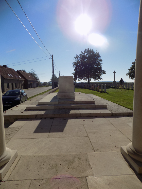
The main entrance is in the right-hand corner of the cemetery between a brick and stone shelter building and the Stone of Remembrance on a raised platform.
There are 8 stone steps from pavement level going up to a paved area around the Stone of Remembrance which is built into the perimeter wall. There is a vertical drop of one metre from the paved area down to the grass verge along the side of the road. The paving from the top of the stairs between the Stone of Remembrance and the Shelter Building leads directly into the cemetery.
There is a stone bench area and Register Box, mounted into an internal wall inside the Shelter. There is a single step up of 100 mm from the paving up into the Shelter.
There is a single step up to the paving surrounding the Stone of Remembrance, with an additional two steps up to the Stone itself.
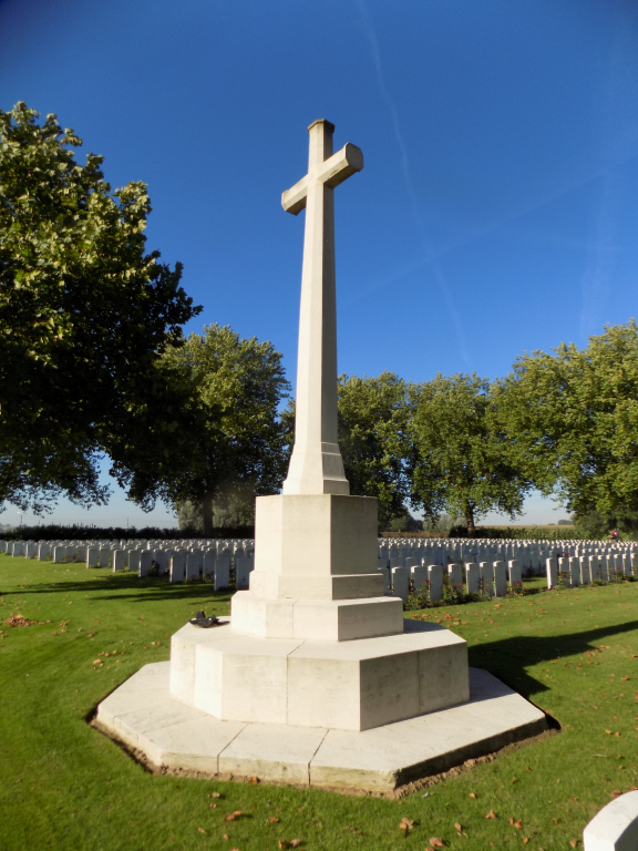
There is a stone bench built into the wall near the shelter building in line with the Cross of Sacrifice on the opposite side of the cemetery.
All internal paths are grass and the ground is firm and level.
ALTERNATIVE ACCESS
Alternative access into the cemetery is through the service entrance approximately 12 metres from the parking area at the front of the cemetery on the left side.
There is a short grass track which curves around the far wall and rises approximate 600 mm to an opening in the wall. There is a strip of paving level with the grass on either side in the opening of the brick wall.
ADDITIONAL INFORMATION
The cemetery is permanently open.
History information
The cemetery was begun in December 1914 by four battalions of the 5th Division and was called at first Wulverghem Dressing Station Cemetery. It was used until June 1917, and again in September and October 1918, and at the Armistice it contained 162 graves, the present Plot I. Graves were then brought in from the surrounding battlefields and the following smaller burial grounds:-
AUCKLAND CEMETERY, MESSINES, on the North bank of the Douve between Messines and Wulverghem, contained the graves of twelve New Zealand soldiers (including nine of the 2nd Auckland Regiment) who fell on the 7th June, 1917.
CORNWALL CEMETERY, MESSINES, 150 metres West of Auckland Cemetery, contained the graves of 21 soldiers from the United Kingdom (including 20 of the 1st D.C.L.I.) who fell in December, 1914-January, 1915.
FRENCHMAN's FARM, WULVERGHEM, nearly 600 metres North of the village, contained several groups of graves; and in them were buried 29 soldiers from the United Kingdom and one French soldier who fell in 1914-15.
NEUVE-EGLISE NORTH CEMETERY was on the Neuve Eglise-Lindenhoek road. It contained the graves of 20 soldiers from the United Kingdom who fell on the 2nd and 3rd September, 1918, and of whom 16 belonged to the 1st Royal Irish Fusiliers.
NEUVE-EGLISE RAILWAY HALTE (or RAILWAY SIDING) CEMETERY was at the light railway station on the South side of the village. It contained the graves of 14 soldiers from the United Kingdom (including seven of Queen Victoria's Rifles) who fell on the 5th January, 1915.
These formed Plots II-V. Within these later plots almost the whole period of the war is represented, in particular the defence of the Kemmel front in April 1918 and the final advance of September 1918.
There are now 1,010 Commonwealth servicemen of the First World War buried or commemorated in this cemetery. 352 of the burials are unidentified, but there are special memorials to two casualties believed to be buried among them and to seven others buried elsewhere whose graves were destroyed in the fighting of 1917-18.
The cemetery was designed by Charles Holden.