Brown's Copse Cemetery, Roeux
- Country France
- Total identified casualties 1213 Find these casualties
- Region Pas de Calais
- Identified casualties from First World War
- GPS Coordinates Latitude: 50.30288, Longitude: 2.88379
PLEASE NOTE
Works on the south wall are now completed, a grass restoration is underway, stay cautious when visiting. Please note that the works on the east wall are planned later this year, around September 2024. The site will stay accessible as well as all the headstones. We apologize for any inconvenience caused.


Location information
Roeux is a village about 8 kilometres east of Arras. Brown's Copse Cemetery is about one kilometre north-west of Roeux on the eastern outskirts of the neighbouring village of Fampoux. It is signposted from Fampoux village.
Visiting information
ARRIVAL
The route to the cemetery is signposted.
PARKING
Parking is along the front of the cemetery, approximately 200 metres from the junction of Rue de la Herse, on a single-track lane. There is no turning area at the end of the track.
The track is narrow (single vehicle width), has a loose gravel and earth surface, the ground is flat and firm.
It is possible to park within 5 metres of the main entrance building.
ACCESS, LAYOUT AND MAIN ENTRANCE
The cemetery is rectangular shaped.
The main entrance of the cemetery is via a large entrance building, through a large archway. In front of the entrance building are grassed raised areas, bound with raised stone kerbs along the track, with a pathway leading to the archway.
There are 2 stone steps from ground level up to the paving that leads through the arch.
The clear opening under the arch is 2 metres wide. There are 2 stone bollards inside the gap which reduces the clear entrance width. Clear spacing between the bollards is approximately 500 mm. On either side of the archway are covered areas, forming part of the entrance building. In front of the areas are planted bastions which are located on the cemetery side of the building
The Register Box is located in the wall on the left-hand side of the entrance building as you enter the cemetery.
Once thorough the arch, the ground surface is flat stone paving, which leads to three steps down into the cemetery. The bastions are located on either side of the pathway and stairs leading into the cemetery.
The Stone of Remembrance is located in the centre of the cemetery, in line with the main entrance and the Cross of Sacrifice, at the far end of the cemetery opposite the main entrance. The Cross of Sacrifice is built on the top of the wall on a raised platform.
There are stone benches located along the east and western boundary walls of the cemetery, as well along the rear wall on either side of the Cross of Sacrifice.
All the internal cemetery paths are grass, the ground is flat and firm.
ALTERNATIVE ACCESS
Alternative access is through a gate at the end of the access track in the far corner of the cemetery, approximately 30 metres from the main entrance along the front wall.
A 2 metre-wide, grey two-leaf metal, waist-high gate has a top sliding bolt handle for the left side leaf and a bottom lift and turn, drop closing bracket for the right side. There is paving under the gate, which opens inwards into the cemetery onto grass.
ADDITIONAL INFORMATION
The cemetery is permanently open.
History information
Roeux was built over a system of caves which helped to make its capture in 1917 exceptionally difficult. It was attacked by the 9th (Scottish) Division without success on 12 April. The chemical works close to the railway station were taken by the 51st (Highland) Division on 22 April and after incessant fighting, the village was cleared by the same Division on 14 May. The chemical works were lost again and retaken on 16 May. The Germans re-entered the village at the end of March 1918, and it was finally retaken by the 51st Division on the following 26 August.
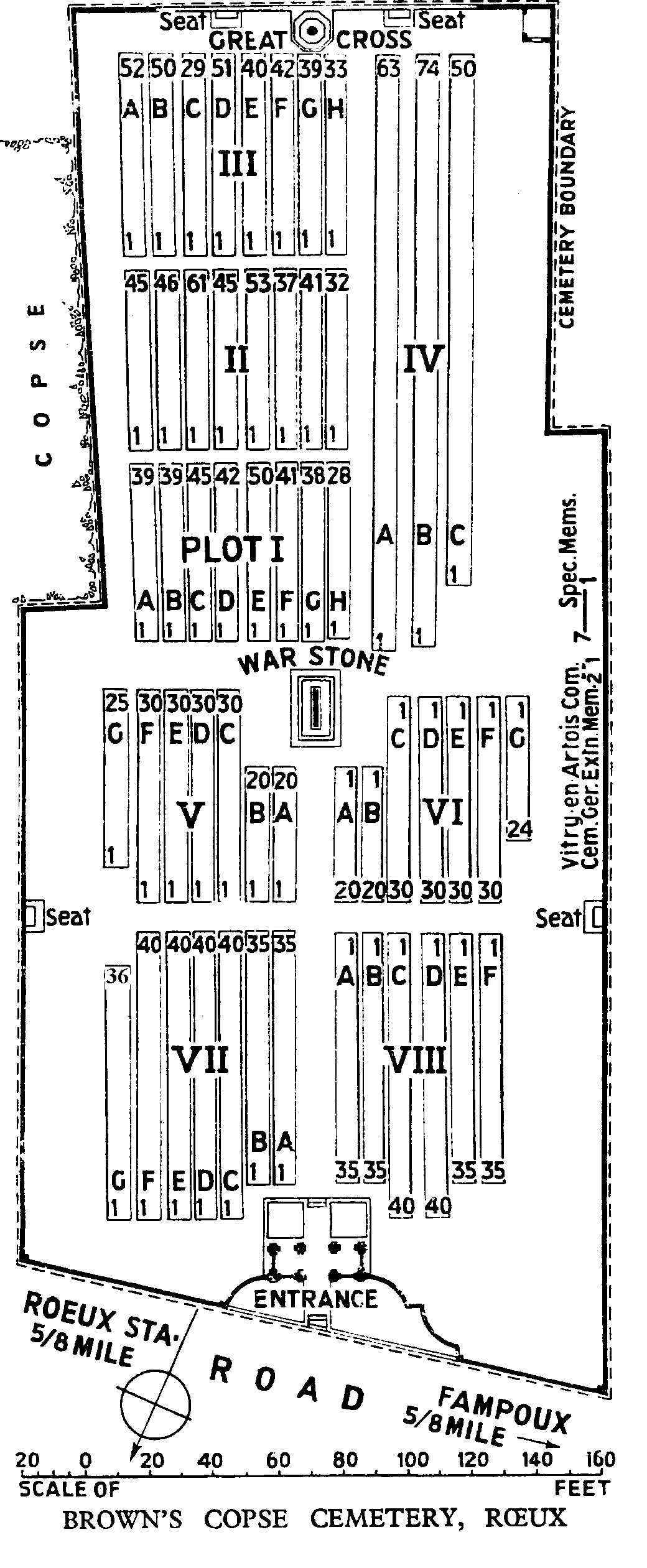
The cemetery is named from a small copse (the Bois Rossignol) on the east side. Plots I to IV are composed almost entirely of graves cleared from the battlefield in the summer of 1917. Plots V to VIII were made after the Armistice when 850 graves were brought in from a wide area north and east of Arras.
The following were the only considerable burial grounds from which British graves were taken to Brown's Copse Cemetery:-
SEAFORTH CEMETERY, ROEUX, North-East side of the road from the village to the station, where 18 soldiers from the United Kingdom were buried in April, 1917, and 21 of the 6th Seaforths in August and September, 1918.
VITRY-EN-ARTOIS COMMUNAL CEMETERY and GERMAN EXTENSION, in which 17 soldiers from the United Kingdom (mainly officers of the Royal Flying Corps) were buried by the enemy.
The cemetery now contains 2,072 burials and commemorations of the First World War. 862 of the burials are unidentified but there are special memorials to eight casualties known or believed to be buried among them. Other special memorials commemorate two casualties buried in Vitry-en-Artois Communal Cemetery German Extension, whose graves could not be found.
The cemetery was designed by Sir Edwin Lutyens.